

Your source for Mountain Biking in the Triangle
Raleigh-Durham-Chapel Hill

|

Your source for Mountain Biking in the Triangle Raleigh-Durham-Chapel Hill |
||||||||
Current Trail Status
| Category | Average Rating |
| Overall : |  3.5 / 5.0 based on 38 votes 3.5 / 5.0 based on 38 votes |
| Technical : |  3.4 / 5.0 based on 38 votes 3.4 / 5.0 based on 38 votes |
| Climbing : |  3.1 / 5.0 based on 38 votes 3.1 / 5.0 based on 38 votes |
| Freeride : |  3.6 / 5.0 based on 38 votes 3.6 / 5.0 based on 38 votes |
| Scenery/Wildlife : |  2.6 / 5.0 based on 38 votes 2.6 / 5.0 based on 38 votes |
| Flow : |  2.4 / 5.0 based on 31 votes 2.4 / 5.0 based on 31 votes |
Description
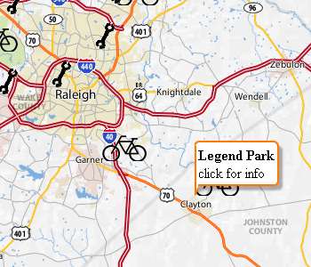
Location: Clayton
Miles: ~ 6
Skill Level: Beginner to advanced. A little bit of everything
here. Freeriders take note. Hucksville is located here. A
skills area has been set up near the parking lot. It has
several skinnies, drops and jumps of varying difficulty.
Map
Park Hours and Fees
Directions
Rules of the trail
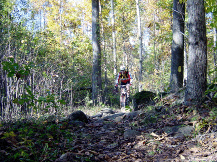
The trails are inside the Town's Legend Park. The property is bordered by a creek and a jeep trail. The trail starts at the corner of a ballfield and takes you along the creek. Fun stuff along the way includes rock gardens, boulders, jumps, and bridges. The trails are multi-directional and offer lots of choices for your route. This trail has a little bit of everything. The trail by the creek is absolutely beautiful.
Park Hours and Fees
No fees. The park is owned by the Town of Clayton. Park
is open from 8 AM to 11 PM.
Directions
From
Raleigh, take I-440 to I-40(South or East) towards
Benson, Wilmington. Take US 70 east towards Goldsboro,
Atlantic Beach. Go into Clayton and go to second stop
light. Turn left onto Robertson Street (McDonalds is on
corner) and take Robertson until it deadends. Turn left
onto Stallings Street, and take second right onto City
Road. Legend Park will be about 1/4 mile on your right.
Look for a kiosk in parking lot, it will tell you how to
get on the trails.
Rules of the Trail
The trail rules are posted at the
trailhead and, yes, you can bring your well-mannered dog
with you.

Night riding is allowed on this trail. Please be off
the trail when the park closes at 11 PM each night.
Trail Descriptions
THE "SKILLS
ZONE"
Beginners and expert riders alike are
trying their luck at the new skills area located in the
parking lot behind the kiosk. Phase I of this area
includes 2 skinnies, one at 8" and one at 12"
wide . While both are of a reasonable height, each one
possesses it's own challenges. Also found in this area is
a 3 prong jump/drop stunt ranging from 1.5' to 3.5' high.
This solidly built stunt will inspire confidence and have
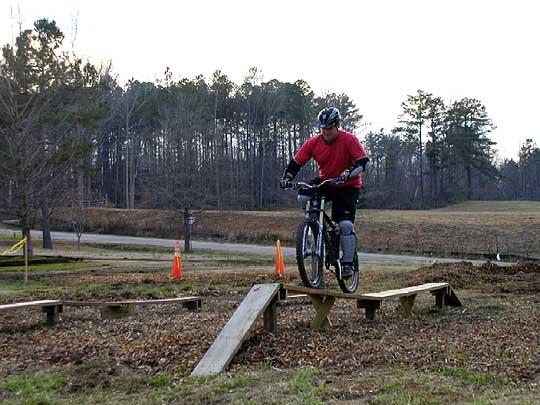
you flying in no time. Phase II includes a zig zag skinny, and three jumps to hone your skills on.
(see pics below)
Main Trail starts at the kiosk,
located at the lower half of the parking lot. This trail
will
give riders access to every trail and blast you
through the "ravine" and take
you by
"Hucksville".
Hucksville is home
to some of the biggest and coolest hucks/drop around. We
have multiple
drops/jumps for the extreme riders to
try. There is a gap jump, gulley drop, the
original
drop or huck(your choice) and the Fatire drop. To total,
there are five options
for defying gravity. Good luck!
Allen's Trail is the first loop off of the
Main Trail. This is a "difficult" rated trail
with lots
of short ups and downs and serves as a
great warm-up for the advanced rider.
The
"Clayton Shore" is at the outer most bend and
gives daring riders over
150' of elevated stunts to
try their luck on.
Short Loop/Long Loop are the original trails
in this system. Low land riding along the
Sims Creek,
several boardwalk section and a couple of climbs
to
keep you honest. Trail features technical rock garden,
multiple
log stacks and various rock obstacles for
play spots on these loops.
All of the above mentioned
trails and considered to be the "lower trails".
Trail rating is "easy" to "moderate".
Harvey's Pond is the first trail in the group
of trails, know as the "upper trails". The loop
rides
along Harvey's Pond and serves as a climb
reliever to the "ravine".
Trail rating is
"moderate".
Little-Big Horn is located at the southern
most end of the Main Trail. Trail features lots of
rolling single track with log stack and a bare-back log
ride.
Trail rating is "moderate".
Larry's Loop is located at the outer most
point of Little-Big Horn and is also at he highest
point of all the trails. This is the other
"difficult" rated trail and features off-
camber sections, narrow bridges and hard climbs to
toughen the challenge.
Magnolias Run is the longest of all the upper
trails and like Little-Big Horn was built to
be
ridden from the top down. Trail features bench-cut
contour riding, several fast
downhill sections and a
double switchback climb. Trail rating is
"moderate".
No trail has a mandatory
direction, riders can ride any trail in any direction.
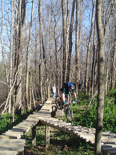
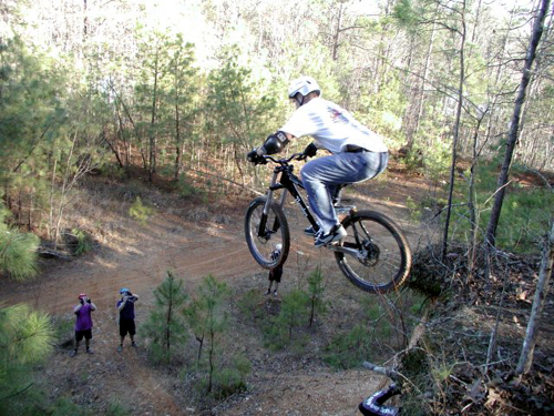
(L) 40 foot skinny located at Legend Park
Allens Trail.
(R) Multiple locations for serious hucks. It's known as Hucksville. Rider is Matt S.
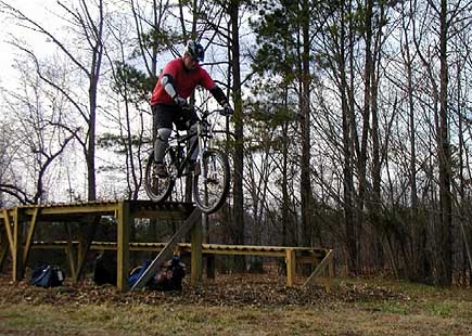 Photo by Larry Bailey |
|
Rules, guidelines, and definitions for our TriangleMTB.com trail reviews
|
The skills park is abandoned and I'm terrible shape. Could not find Magnolia trial, maybe someone can share clearer directions or coordinates? I checked up and down the Greenway that starts in the parking lot that this page directs you to. | ||||||||||||||||||
|
Absolutely garbage. Looks like nobody has ridden there in 20 years. Sign to the trail was covered by 7ft high grass. Wooden structures are a joke and total liability to use. All of them are falling apart. It’s actually embarrassing this website added this “park” as a place to mountain bike. Trails are totally unmarked and unmaintained. Don’t waste your time and go somewhere else. | ||||||||||||||||||
|
First time riding Legend and it was great! Lots of roots and rocks to challenge you and some decent climbs. Hucksville is a fun drop to get the blood flowing and the little jump lines are fun. I'll be back out here for sure! | ||||||||||||||||||
|
No detailed review given. | ||||||||||||||||||
|
Legend Park reminds me of that high school friend that was not that popular, but was honest, reliable and helpful. This trail might not be as fancy and well maintained as crabtree or other trails in the area, but isn't mountain biking about that? This is the rawest, natural-like and demanding (cardio) trail you will find in the area, definitely not a place for beginners (You are required some basic skills so you can enjoy this trail at its highest level) you may feel frustrated if this trail is your first MTB experience. Now let's talk about the trail: This jewell is divided in two sections, upper trails and lower trails and each area has its own loops...In both areas you will find short but at the same time demanding climbs, fast rooty and rocky descents, berms, switchbacks, drops, roots, and more roots. Between the upper and lower trails there is a new jump line (dirt jumps for sloop style) with 3 or 4 jumps. By the way, that skills area from the pictures, does not exist anymore. Make sure ride the whole thing, you will find nice features all over the place. | ||||||||||||||||||
|
I and a few others have busted our butts to get Legend in riding condition for the spring. I will work to get some updated pictures of the trail added to the trail page. Many of the wooden structures shown in the pictures online have been removed. The trails are mostly for intermediate level riders, though sections of the lowers are appropriate for beginners. These trails consist of many fall line routes, switchbacks, kickers, rocks, and large awesome roots.. how trails used to be! The trails have seen a lot of maintenance as of recent and more riders have been coming out. There is a new jump section and some new trails/reroutes of areas subject to flooding. Several of the bridges were repaired. Trail markers have been repaired/replaced. Overall, this is my favorite place to ride in the Triangle. | ||||||||||||||||||
|
This page needs to be updated. I decided to check this trail out recently and was sorely disappointed. From what I can tell the park is no longer maintained as it once was. Most of the wooden features shown in the pictures no longer exist. Many of them were practice features outside of the trail which I think are all gone. Many are also features on the trail like bridges which are either gone or rotten and falling apart. The hucksville section of this trail is also in disrepair and quite dangerous to ride at the moment. The wooden extensions are falling and unsafe. The trees and plants have grown up around the trails to make them dangerous. One thing is the wooden berm at the bottom of the hucks seems to still be in decent shape! Overall this place has a lot of potential. One of the only trails in the area which could make it a destination for people east of Raleigh who don't want to deal with the traffic of getting to the other popular trails. Hopefully I just went at a bad time and the trail will soon return to its former glory. | ||||||||||||||||||
|
Fun trails. Wish they were maintained a little better. Trails are not marked marked very well so it is challenging to find a loop without someone to show you the way. On the "Upper" section there is some moderate climbs. I consider myself an intermediate rider and was able to ride the more difficult sections without overly exerting myself. Hucksville is cool if you have never had a chance to get much air. Nice drops here and it is close to the parking lot in case you destroy yourself. The "Lower" section had a couple rock gardens but nothing significant enough to require a lot of effort. This section is considerably flatter and much more suited for beginners than the Upper. If you live close to Clayton then you should check it out. I live in southwest Raleigh and probably will not drive the 20-25 minutes out there again. Don't get me wrong, I had fun, but I was expecting more from what everyone I have spoken to has told me about this park. A little underwhelmed... |
||||||||||||||||||
|
This trail has gone downhill due to lack of maintenance. It is nice to have a trail in your town so I enjoy riding it anyways. Big thanks to whoever added the couple of jumps and the berm on the upper trail! |
||||||||||||||||||
|
When you arrive at the park. There are no signs letting you know where to go, or which trails are which, or even the difficulty of the trail you are about to ride. Trails are still easy enough to find, just head for the woods. Trails could definatly use some maintenance (especially the man made features). The only markings I could find were a few orange or yellow markings along the trails. Even with those markings, the trails branch off so much it's very easy to end up on a different trail and not know it. After exploring these trails, I would recomend if you haven't been here, ride them with someone who knows them. Beware of trail dangers until the trail has been fixed, I found multiple areas with broken glass, vines hanging across the trail, and even a metal sign post sticking out of the ground. I'm sure the trail is good if you know where to ride, if you don't, be careful | ||||||||||||||||||